About Kuari Pass Trek — Lord Curzon Trail, Chamoli
Kuari Pass Trek, also known as the Lord Curzon Trail, is a moderate Himalayan trek in Chamoli, Uttarakhand, celebrated for the most spectacular panoramic view of high Himalayan peaks accessible on a moderate trail in Garhwal. The trek starts from Dhak Village near Joshimath and climbs to a maximum altitude of 3,641m, covering 24 km over 4N/5D. Best season: April–June · September–November.
At Kuari Pass, trekkers are rewarded with an unbroken 180° panorama that includes Nanda Devi (7,816m) — India's highest peak within its borders — alongside Dronagiri (7,066m), Kamet (7,756m), Hathi-Ghoda Parvat, Nilgiri Parvat, Bethartoli and Mana Peak. This concentration of high peaks visible from a single vantage point is unique in Uttarakhand trekking and is what earned this route Lord Curzon's famous declaration that it was "one of the finest walks in the world."
The trail passes through the alpine meadow of Khulara (3,640m), dense oak and rhododendron forests of Chitrakantha, and open pastoral land at Gorson Bugyal near Auli. The classic route runs from Joshimath → Dhak → Gulling → Khulara → Kuari Pass → Tapovan → Auli — allowing a beautiful point-to-point trek with a cable car descent from Auli as an optional highlight.
Tour Venture India, a GST-registered travel agency based in Haridwar, offers fully guided Kuari Pass Trek packages starting from ₹8,999/person, including certified mountain guide, all meals on the trail, accommodation, and all required permits. WhatsApp +91-8057146497 for a customised itinerary and free quote within 30 minutes.
Kuari Pass Trek Highlights
Kuari Pass Trek — Route & Day-by-Day Itinerary
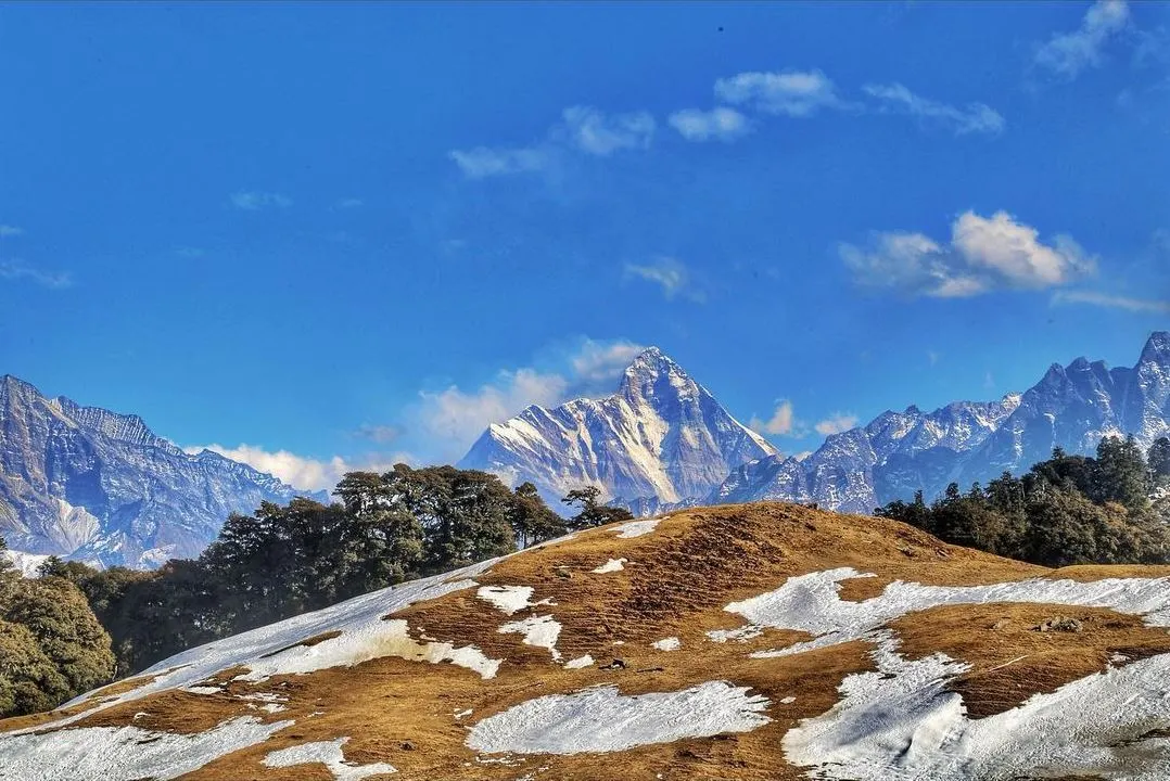
The Kuari Pass Trek classic route runs from Dhak Village near Joshimath to Auli, crossing Kuari Pass at 3,641m. Total distance: 24 km over 4N/5D. The base town is Joshimath (1,890m), which is 294 km from Haridwar on NH-7 (Badrinath Highway).
Drive from Joshimath to Dhak Village (6 km, 20 min). Meet your certified mountain guide, complete gear check and permits. Short acclimatisation walk to Gulling meadow (2,100m). Overnight at Gulling camp. Distance: 4 km trek. Altitude gain: ~200m.
The longest ascent day. Trek from Gulling through dense oak and rhododendron forest, then into open alpine terrain to Khulara (3,640m) — a stunning highland meadow camp with direct views of Nanda Devi. Distance: 10 km. Altitude gain: ~1,540m. Duration: 7–9 hrs.
Early start for Kuari Pass (3,641m) — the panoramic viewpoint of the Lord Curzon Trail. On clear days, view includes Nanda Devi, Dronagiri, Kamet, Hathi-Ghoda Parvat, Nilgiri Parvat and Bethartoli in one unbroken arc. Descend to Chitrakantha (3,300m) for night camp. Distance: 8 km. Duration: 6–7 hrs.
Descend through beautiful forest to Tapovan village (2,650m), passing through Gorson Bugyal — a wide alpine meadow near Auli. Option to continue to Auli for ropeway descent (optional highlight). Distance: 6 km. Duration: 4–5 hrs.
Morning drive from Tapovan/Auli to Joshimath (8–12 km, 30–40 min). Trek concludes. Drive onward to Haridwar (294 km, 8–9 hrs) or Rishikesh (254 km). Tour Venture India vehicles depart from Joshimath.
Best Time for Kuari Pass Trek
The best seasons for Kuari Pass Trek are April–June and September–November. The pass and surrounding bugyals are at their most beautiful during rhododendron bloom (April–May) and post-monsoon clarity (September–October).
April–May: rhododendron forests in full bloom on the lower sections. Clear peak views from Kuari Pass. September–October: post-monsoon clarity, stable weather, golden meadows. November: possibility of early snow at the pass — dramatic but gear-intensive.
Monsoon season. Heavy rainfall on the Badrinath Highway and on the trail. Leeches active below 2,500m. Landslides possible on approach roads from Joshimath. Views blocked by cloud. Trek not recommended.
Heavy snow from Khulara upwards. Kuari Pass itself is often under 2–4 feet of snow. Only experienced snow trekkers with microspikes, gaiters and cold-weather camping gear. Tour Venture India offers special winter Kuari Pass treks — WhatsApp for details.
How to Reach Joshimath for Kuari Pass Trek
The trek base is Joshimath in Chamoli, Uttarakhand. Joshimath is 294 km from Haridwar on NH-7 (Badrinath Highway) and 254 km from Rishikesh. Tour Venture India packages include pickup from Haridwar or Rishikesh.
Delhi → Haridwar → Rishikesh → Devprayag → Rudraprayag → Joshimath via NH-7 (Badrinath Highway). Overnight drive recommended. Tour Venture India can arrange Delhi-to-Joshimath private cab — WhatsApp +91-8057146497.
From Haridwar (294 km) or Rishikesh (254 km) via Devprayag and Rudraprayag. The road passes through the spectacular Alaknanda and Bhagirathi gorges. Drive time: 8–9 hours depending on traffic at Devprayag and Rudraprayag.
Fly to Jolly Grant Airport (Dehradun) from Delhi (45 min), Mumbai or Bengaluru. Drive from the airport to Joshimath: approximately 300 km, 8–9 hours via Rishikesh–Badrinath Highway. Tour Venture India airport pickup available.
Haridwar and Rishikesh are the nearest railway stations (Haridwar has better connectivity from Delhi, Mumbai and other cities). From Haridwar, hire a private cab to Joshimath (294 km, 8–9 hrs). Tour Venture India packages include pickup from Haridwar station.
Essential Tips for Kuari Pass Trek
- Acclimatise at Joshimath (1,890m) — Spend at least one night in Joshimath before starting the trek. The town sits at 1,890m and helps your body prepare for the rapid ascent to Khulara (3,640m) on Day 2.
- Day 2 is the hardest day — The Gulling-to-Khulara ascent gains ~1,540m of altitude in one day. Start by 6 AM, pace yourself, and take short breaks every 30–45 minutes. Never rush above 3,000m.
- Carry warm gear even in summer — Khulara and Kuari Pass can drop to −5°C at night even in May. Carry a down jacket, woollen gloves, thermal base layers and a balaclava. Winds at the pass can be sharp.
- Start each day before 7 AM — High-altitude weather on the Kuari Pass route often deteriorates by afternoon with cloud build-up and wind. Early starts ensure the clearest views and safest conditions at the pass.
- Ankle-support boots are essential — The descent from Chitrakantha to Tapovan is steep and rocky. Trekking sandals or sports shoes are dangerous. Invest in proper Vibram-soled ankle-support boots.
- Know altitude sickness (AMS) signs — Persistent headache, nausea, dizziness or difficulty breathing at altitude. Never ascend with AMS symptoms. Descend 300–500m immediately if symptoms worsen. Tour Venture India guides carry a pulse oximeter and basic AMS medication.
- Permits required — Kuari Pass falls within Nanda Devi Biosphere Reserve buffer zone. Tour Venture India handles all forest and trekking permits — no need to arrange separately. Do not enter without permits.